Food Lion to Lake Anna
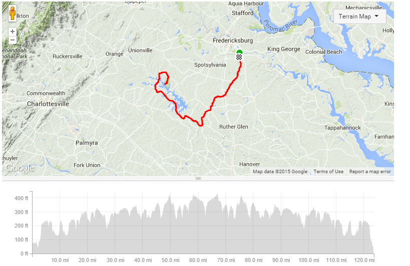
Miles: 126
Elevation: 5500
Map
Elevation: 5500
Map
| Rest Stop | Mile | Restroom |
| Convenience Store | 8 | Yes |
| Convenience Store | 24 | No |
| Convenience Store | 31 | Yes |
| Convenience Store | 42 | Yes |
| Food Lion, Subway | 48 | Yes |
| Convenience Store | 50 | Yes |
| Store/Restaurant - View of Lake | 54 | Yes |
| Lake Anna State Park | 63 | Yes |
| Turn | Mile |
| Benchmark Rd | 0.0 |
| L - Cahill St | 0.4 |
| L - Slingerland Dr | 0.8 |
| L - Napolean St | 0.9 |
| R - Schumann St | 0.9 |
| R - Jim Morris Rd | 1.2 |
| R - Stonewall Jackson Rd | 8.9 |
| L - Edgehill Academy Rd | 10.2 |
| R - Paige Rd | 13.4 |
| L - Cedon Rd | 13.7 |
| L - Countyline Church Rd | 18.8 |
| R - Ladysmith Rd | 23.1 |
| L - Anderson Mill Rd | 23.8 |
| R - Beaverdam School Rd | 29.6 |
| R - Kentucky Springs Rd | 37.1 |
| L - New Bridge Rd (208) | 48.4 |
| R - Zachary Taylor Hwy (522) | 49.8 |
| R - Days Bridge Rd | 50.8 |
| R - Jones Powell Rd | 56.2 |
| R - State Park Ln | 60.0 |